
County priorities?
Healthy living, well being,
safety, security, thriving communities,
environmental stewardship
Comprehensive Plan what was called such in 1989, and the road was shown there as well.
 Project costs should run between $50 and $75 million. “Staff anticipates acquiring right-of-way for the East-West Freeway as early as Spring 2018,” Smith said.
According to Smith, since the Banners Station case in 2006, there has been a cloud hanging over some property owners along the major road alignments.
“We need to give them the benefit of being proactive and making good on their homes,” Smith said.
The Southern Air Line (SAL) railroad once split the proposed Matoaca Mega Site, and the rail bed the transportation mega company left behind is now a 10-foot cutthrough of the 1,675 acres slated for the home of industry.
Heading south in a straight line parallel with Branders Bridge Road, what now looks like a well-traveled old dirt road skirts east along a huge natural lake created by an earthen dam constructed by the SAL in lieu of a bridge. The shadows of pine, oak, and magnolia crawl from the banks creating cool hiding places for its abundance of fish.
In the mid-1900s, the SAL passenger trains almost took flight at over 100 miles per hour as they passed through Chester, the traveler barely seeing one of the hidden treasures of Chesterfield. But the same steel rails also carried the materials of industry – citrus, forestry products, paper, and steel.
The Matoaca Mega Site is not only a plot of land that could be the location of new industry of the highest use, but rail will access just as the SAL did so many years ago. The rail with its adjacent road, according to Chesterfield’s Economic Development, will change southeastern Chesterfield in ways which only 5,000 new jobs for the community can do.
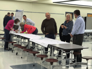
More houses, more businesses, more crowded schools, more traffic, and loss of property. These are the arguments or issues discussed at Monday night’s meeting.
In 2006, the Branners Station rezoning for the 1,675 acres turned the rail bed into a north-south major arterial that ran from the proposed Mega Site and ended at the railway abutments on Chester Road supposedly to reduce traffic issues. Two years later, the economy crashed, and the Branners Station developer canceled the project. In 2012, County’s Comprehensive Plan included the property as R-12, its residential zoning. But in the same Comprehensive Plan, the Bikes and Trails plan indicates that the Linear Park Trail, the same railroad bed that runs through the Mega Site is still shown on Comprehensive Plan maps.
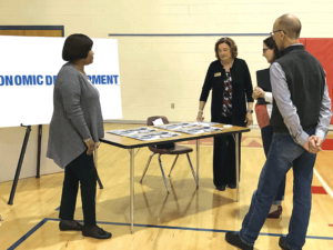
“It’s a game changer for us and the region,” said Garrett Hart, director of the Economic Development Authority of Chesterfield County. “We want projects that attract millennials, but it’s not my job to convince anyone.”
Michael Uzel, founder of the Bermuda Association for Responsible Development, asked Hart in an e-mail about the short amount of time between the Mega Site announcement and the rezoning hearing that is needed for industrial to be located there.
“We will not place our application on the Planning Commission agenda until it is complete and includes the information from our studies and public input,” Hart responded. “We filed the rezoning application to start the process which allowed us be part of the October Planning Commission meeting agenda.”
Hart said he didn’t expect the negative response to the rezoning.
Chesterfield Transportation Department Director Jess Smith said his department has been analyzing possible East West Freeway routes for a year, and before that when the rezoning for the mega residential development Branners Station with 5,000 homes was to be built.
“All of the conceptual alignments were shown on displays at the first public meeting and will be provided at all future meetings,” Smith said. “The analysis of the impacts of these alignments will also be provided,” he added. Smith also said he has been working in the transportation department for 15 years, and the East-West Freeway and the Comprehensive Plan map have always been on the map. He continued that he went back to what was the first
