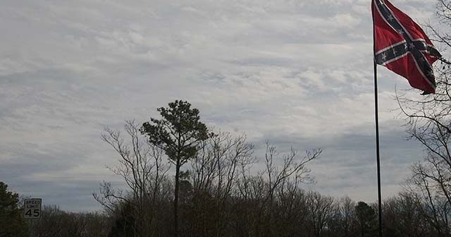
A request for a conditional planned-use development that would allow for a 600-square-foot Confederate battle flag to fly atop a 112-foot pole next to Interstate 95 was withdrawn last week.
The Chesterfield County Planning Commission was scheduled to consider a request from Susan L. Frise and the Virginia Flaggers, but it was withdrawn June 16, according to planning administrator Joe Feest.
A smaller version of the flag had flown above a narrow sliver of property next to the interstate for at least six years before it and a 70-foot flagpole were removed late last year after the county won three zoning violation cases against the property owner, Catherine Hendricks, in Chesterfield General District Court.
Hendricks was convicted of three misdemeanors on Sept. 10 for an unpermitted use, not maintaining a setback requirement and a structure exceeding 50 feet. She appealed to circuit court, and the convictions were dismissed on Jan. 3 with $382 in costs, according to courts.state.va.us. The complainant was listed as Theodore Barclay.
That followed a determination by the Chesterfield County Board of Zoning Appeals in February 2019 that upheld the determination of planning director Andrew Gillies. Zoning violations were issued in February and September 2018, the latter after Hendricks purchased the property.
According to a planning document, staff recommended denial of the conditional planned use development. The applicant requested a 62-foot height exception for the flagpole, for the pole to be a principal use on the property and for a flag use exception for a non-commercial flag on agriculturally-zoned land at 2501 Old Bermuda Hundred Road.
A March 9 community meeting had one person in attendance. That person supported the application.
A 50-foot flagpole could be approved for the property if the setback requirement were met and the flagpole were a secondary use, which could happen if the owner would move the pole farther from the road and plant a crop, a planning document states.
A building permit that allowed a 50-foot flagpole was approved in October 2013 without review from the planning department. According to a planning document, between late 2013 and early 2017 the approved flagpole was replaced with a 70-foot flagpole without an approved building permit.
The Goodrich River Trust property approval
The planning commission unanimously recommended approval of a zoning district map amendment for the applicant, Carrie E. Coyner (trustee), for a 23.9-acre property at 1600 Ashton Park Drive.
Planning staff recommended approval with six conditions, including a reduction from 200 to 100 feet for a setback off Ruffin Mill Road, retention of old growth trees, an 8-foot chain link fence that would be screened by a 630-feet-long evergreen hedgerow and a 4-foot berm along Ashton Park Drive with an 8-foot chain link fence and evergreen trees.
The Goodrich River Trust plans to build a 10,000-square-foot construction office/storage building with a storage yard on the northeast corner of Ashton Park Drive and Ruffin Mill Road.
During public comment, Abraham Nelson spoke against the project. Nelson, who said he moved into the area in 1979 with his parents, said he was representing 12 households from Ruffin Mills Estates. All but one of area property owners supported him, Nelson said. “It will create an eyesore,” he said of the project. “We don’t necessarily want to see a chain link fence and evergreens.”
The property was rezoned from agricultural to industrial (I-2) in November 1987.
Matoaca District commissioner Tommy Owens noted that the current zoning allows for a 75-foot setback, which is less of a distance than the current application requests. Bermuda District commissioner Gib Sloan added that the project is significantly enhanced over what the current zoning ordinance allows.
The site, which is near the Appomattox River, has been noted as a possible location for a fourth water source for the county. A wastewater treatment plant at the site has been estimated to cost $121 million. A study by Arcadis Consulting of Richmond in early 2019 considered 11 potential sites for the water treatment plant and recommended one in the Ashton Creek Business Center.
The first phase of the project is estimated to take 10 to 15 years, including two to three years for permits and testing.
Owners of the Goodrich River Trust are Coyner’s father, George P. Emerson Jr., along with Gopinath R. Jadhav of Richmond, P. Jagan Reddy of Petersburg, and Sidney M. Harrison and Raymond N. Harrison, the latter two from Chester.


