By Janit Potter and Walt Heyer
The James River is one of the most historic rivers in the United States, with artifacts located along its shores dating back eleven thousand years. The river has always been a rich resource and heritage for Virginia and its people. From the time that Native Americans lived along the banks of the James, it was a vital part of the livelihood of Virginia, and it continues today to be an important part of the state’s economic development.
Long a fertile waterway for the Powhatan Indians and other tribes, the river became the cradle of English settlement in Virginia and the New World, beginning with the Jamestown settlement. When the Virginia Company of London sought to find a more advantageous location to replace Jamestown as the seat of English life in the colony, they chose an area below the falls and called it the Citie of Henricus. This settlement became the beginning of an American way of life as we know it today. Other settlements such as Bermuda Hundred, Upper Hundred, Digges Hundred, Sheffield Place, and the Falling Creek Ironworks were all formed during the early 17th century around what became Richmond.

The Feeder ship Reykjafoss heads downstream from Richmond to Hampton Roads on June 11, 2010, as seen from the Dutch Gap Canal. (John Meckley).
Today, the James River flows differently from when the Citie of Henricus was founded. Sir Thomas Dale began to transform the land of Henricus in 1611 when he employed a Dutch fortification technique to dig a ditch or moat and construct a paled fence behind the ditch, which protected the Citie. The land masses on either side of the ditch became known as Dale’s Dutch Gap.
The river at Dutch Gap again made history during the Revolutionary War when Benedict Arnold, then a general in the British Army, captured or sank the Virginia Navy at a site known as Osborne’s Landing.
During the American Civil War, the James River near Richmond was protected by Confederate batteries, severely hampering the Union Army.
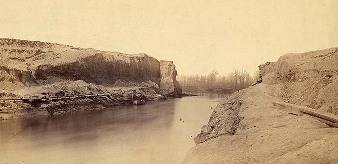
It was during the Civil War that Union armies under the direction of Gen. Benjamin Butler devised a plan to build a canal across the original site of Dutch Gap to move the Union Navy out of harm’s way. Construction of the canal began in 1864. Approximately 15,000 cubic yards of soil were removed by hand from the gap. An explosion Jan. 1, 1865, breached the dam. Shortly thereafter, heavy rainfalls opened the Dutch Gap canal to small vessels, cutting the time and length of the trip along the James River.
After the war, the James River returned to commercial and private use. The United States government appropriated funds for the U.S. Army Corps of Engineers to improve the Dutch Gap passage. By 1871, the canal was 18 feet deep and 100 feet wide, allowing the steamship Sylvester to lead a celebration procession through the canal.
During the 1930s, the James River was further straightened, and the Dutch Gap Canal was extended to the current location of the Chesterfield Power Plant operated by Virginia Power. This additional canal work eliminated a large loop in the river and created Hatcher’s Island to the north.


